TroutRoutes: Fly Fishing Maps

TroutRoutes: Fly Fishing Maps

By Trout Insights, LLC

  • Category: Navigation
  • Release Date: 2019-03-04
  • Current Version: 5.0.13
  • Adult Rating: 4+
  • File Size: 123.12 MB
  • Developer: Trout Insights, LLC
  • Compatibility: Requires iOS 16.0 or later.
Score: 4.62129
4.62129
From 3,137 Ratings

Description

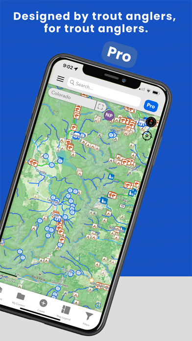
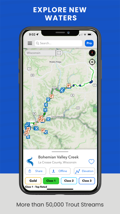
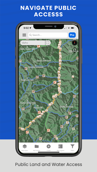
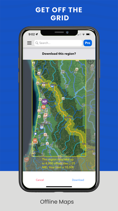
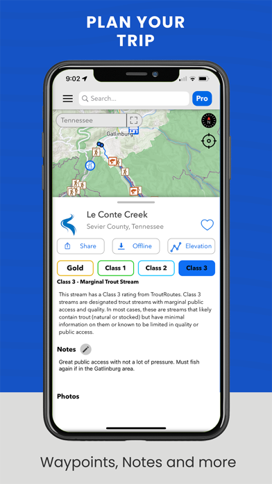
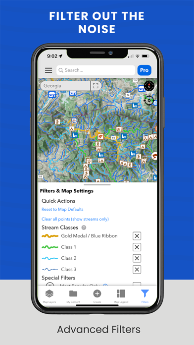
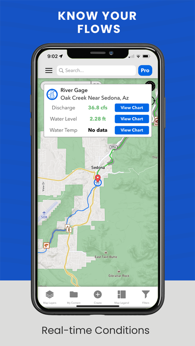
TroutRoutes is the #1 GPS mapping tool for trout streams and fly fishing. It is the industry's first mapping tool that includes interactive GPS fishing maps for every trout stream in the continental United States, providing comprehensive information for each stream and river. Today, TroutRoutes has detailed access maps of over 50,000 trout streams, quickly becoming one of the most useful GPS maps within the fishing app category. Our top features include: - Interactive Trout Streams: Industry's first comprehensive and interactive map of every stream and river that inhabit trout, with detailed local information for each stream. - GPS and Directions: Get real-time GPS and driving directions to know where you stand and avoid private property. - National Trout Quality Classification System: Industry's first national river classification system based on many factors, including habitat quality, access opportunities, trout species abundance, and more. This color-coded quality system helps anglers quickly explore the top waters in the U.S. - Public and Private access: intuitive and comprehensive public access layers, including fishing easements, national forest, local parks and any other parcel boundaries that offer public access to trout streams. - Access Points: Over 500,000 unique and hand-curated access points for every stream, including parking locations, bridge access, public access routes, trailheads, boat ramps, put-ins and other designated access points. - Fly Shops and Fishing Stores: Find and interact with local fly shops around the country. We have every shop with interactive links to websites and directions, everything you'll need for your next fly fishing adventure. - Interactive Elevation Charts: Provides slope and contour details for every stream and river. This feature helps anglers understand rivers before getting to the water, including detection of tailwaters, reservoirs, headwaters, meadows and other important river features. - Real-time river flows and gage charts: Get real-time river flows and charts with our USGS gage layer. - Offline Maps: No internet? No problem. Take our interactive maps completely offline with our offline maps. Available by river or region. - Personal Content and Markers: Create custom maps by leveraging our mapping tools that allow you to save notes, customizable private markers and shapes. - Regulations: See detailed special regulations for rivers around the country, and leverage our Regulations Map overlay to see color coded regulation sections for each state. Our mapping tool is now endorsed and sponsored by fly fishing professionals and industry partners. You can find more information about our product in local fly shops such as Orvis. Get started for free with our Basic Plan or start a free week trial of PRO to leverage the features listed above.

Screenshots

Reviews

  • Unresponsive Company, Still Waiting

    1
    By N_Stein
    Created an account 3 days ago and they happily took my credit card, even got the email that said they received everything. However, I have been unable to actually login and take advantage of the Pro features as I get “email not recognized” every time I try to login. I have reached out four times through their website support and have heard nothing back from them. I am extremely disappointed. If they contact me and make everything right, I will update this review, but at this moment, I recommend this app to no one.
  • Ng

    1
    By Troutchaser54
    Log in never works
  • Kyle Lantz

    3
    By kyle lantz
    I wish we could see depth of lakes and bigger rivers
  • Regular Google Map with random spots!!

    1
    By Art_Mavr
    Whatever you see in the promotion for paid plan is not there. Basic plan is just a google map. And all you get with “pro” plan is random “fishing” spots on rivers with no additional information whatsoever. $56 absolutely for no value!
  • New to trout fishing.

    5
    By Lafco1274
    I am a true rookie when it come to trout fishing. There are no trout streams within 100s of miles of my home. It is nice to see areas to camp and fish. Planning to make multiple trips this summer and will see how well the app works.
  • Highly recommend👍

    5
    By ethab m
    If you fish year round, this app is worth it. Only fishing app i have needed for trout fishing colorado, i pay for the year subscription. Offline maps is a big bonus for backcountry fishing trips.
  • Where is Florida ?)))

    1
    By Pbwkc
    Urudjjf
  • wayy to expensive!

    1
    By jakeyyy666
    theres nothing on this app that isnt free through the dnr.. so why pay for this app?? and at the ridiculous prices they want to use this? no way, do not recommend
  • Was 4 Stars

    4
    By paradiserises
    I loved the basic when you could touch a creek or stream and it told you what Class the waters were. That’s all I needed. Gold Medal, Class 1, 2 or 3. With the update it’s very cluttered. Now you got to pay a dollar. Rich Men North of Richmond.
  • Useless now

    3
    By Soccer/Lax/Football
    This used to be a great app but now has gone down hill. When I first stated to use troutroutes it would let you see the rating of the stream what you should throw and other things that would make your fishing more successful. Now the only thing that you can do without upgrading to pro ($60 pre year) is look at a map that shows the labels of the stream. If you go to open it out it just tells to to get pro. FIX THIS.

keyboard_arrow_up